This past fall quarter, the College of Computing & Informatics (CCI) launched a new center to promote interdisciplinary approaches to geocomputation and data analytics through research, education and outreach.
The Center for Spatial Analytics and Geocomputation (CSAG), led by CCI Professors
Tony H. Grubesic, PhD and
Alan T. Murray, PhD, is pioneering new methods and analytical techniques to solve computationally-intensive geospatial problems and provide open-source software tools focused on spatio-temporal prediction, real-time navigation, context-aware computing and sensing, geosurveillance, geo-privacy and geovisualization.
Grubesic previously served as associate professor in the former College of Information Science and Technology at Drexel. Murray, who joined CCI this past fall with a joint appointment as professor in Drexel’s School of Public Health, previously served as professor at School of Geographical Sciences and Urban Planning at Arizona State University, where he was also a member of the Industrial Engineering Graduate Faculty in the School of Computing, Informatics, and Decision Systems Engineering, as well as a senior sustainability scientist in the School of Sustainability.
Through the development state-of-the-art tools and techniques for the collection, fusion, curation and analysis of geospatial data, the Center aims to educate the next generation of computational (social and environmental) scientists and engineers through cutting-edge coursework and research that emphasizes spatial-temporal reasoning, visual support and understanding, and policy-relevant insights.
CSAG’s research initiatives are mostly centered on improving society, the environment and infrastructure that surrounds us; this common goal, paired with the Center’s interdisciplinary structure, enables researchers to conduct applied research across the country, break free of traditional academic boundaries and conduct meaningful applied research using geospatial technologies and techniques as the foundation for empirical inquiry.
Grubesic and Murray conducted a national-level geospatial
analysis of diabetes prevalence and its connection to lifestyle data, which identified “hot spots” and “cool spots” of diabetes incidences. They’ve also examined ways to save U.S. taxpayers millions of dollars by developing a mathematical model, combined with GIS technology,
to identify airport location scenarios in the federal government’s Essential Air Service (EAS) program, which allocates subsidies to commercial airliners to provide air service to rural communities in the U.S.
CSAG researchers are also deriving geospatial data to make our cities safer and healthier using aerial vehicles (UAVs), more commonly known as drones. As cities will often cut costs by tapering municipal light schedules or removing infrastructure, Murray is gathering data to support planning and decision making that would affect crime, perception, electrical consumption and safety. Researchers are using images taken by drones flying over San Diego to map the existence of light/darkness across the city with the help of a geographic information system (GIS).
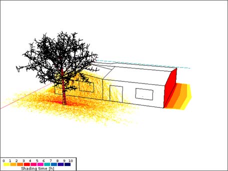
Similarly, Murray is working with researchers in Arizona to analyze the use of shade to enhance public health. In Arizona's hot, arid climate, heat can pose a dangerous threat to human health, especially to at-risk populations, such as the elderly, who may not have access to climate-controlled environments or cannot afford to cool their house. According to the Arizona Department of Health Services, almost 1,500 deaths were caused by heat illness in Arizona from 1992 to 2009, with over 37 percent of deaths occurring in older adults over the age of 65. By flying a drone over residential areas, researchers are able to gather remotely-sensed imagery (of shady or sunny areas) and pair that information with GIS data to determine health outcomes where shade is provided.
GIS technology has also been used to improve educational outcomes, as seen in Grubesic’s two-year "Geographic Information Librarianship" project (GIL) funded by the institute of Museum and Library Services’ (IMLS) Laura Bush 21st Century Librarian Program. In collaboration with the University of Tennessee, Drexel’s GIL project is working to integrate GIS into library and information science curricula at the two schools, as librarians are increasingly called upon to manage and preserve the resources created by an array of geo-location tools.
CCI PhD in information studies students are also engaged in research at the CSAG, such as
Fangwu Wei who is utilizing GIS data to improve transportation networks, and
Jake Nelson who is exploring vulnerabilities and impacts to coastal communities after deep and ultra-deep water oil well blowouts in the Gulf of Mexico.
The Center has also leveraged its research and technologies to impact the immediate Drexel community. Through CSAG’s work with
Lucy Kerman, vice provost for University and Community Partnerships, Drexel is developing a better understanding of the local resources (or lack thereof) in the Mantua neighborhood, through the use of GIS technology. This includes the efforts to identify local student populations, the impacts of Drexel’s Home Purchase Assistance Program and other University efforts to enhance neighborhood engagement.
For more information on the Center and contact information for collaboration opportunities, please visit www.drexel.edu/cci/csag.
###